
Chua Chan 837m, 2nd highest mountain in South Vietnam is a pleasant getaway from the bustling Saigon
- Gypsytracker
- Dec 15, 2024
- 8 min read

Updated: Mar 9
Chuan Chan Mountain, located in Dong Nai province near Gia Ray town, is a picturesque escape just 80 km from bustling Saigon. The town is connected to Saigon via the CT01 highway, which crosses the Dong Nai River and passing lush greenery, rubber tree plantations and vast paddy fields, all with smooth and hassle-free traffic. Approaching the town, we were greeted by the sight of a massive peak rising dramatically above the fields. Its lower half was enveloped in thick clouds, leaving only the striking three-pointed summit visible against the sky. #chuachan
We stopped for breakfast before heading to the foothills. During the short drive through town, I caught glimpses of numerous Catholic churches, houses, and shops adorned with nativity displays, all in preparation for the upcoming festival next week. It was clear that Christianity has a stronger presence here compared to Saigon.
It is hard to imagine but this mountain and the surrounding area was a battleground during the WAR in 1975. Parts of the summit of Chua Chan was blasted away and was used as a communication base by the US Army.
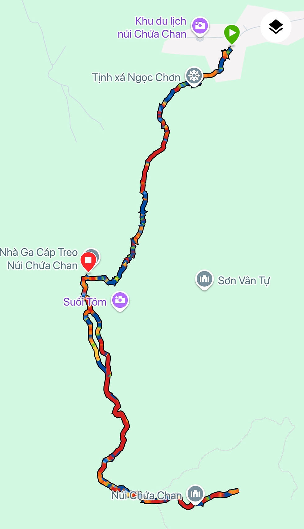
There are three routes to reach the summit of this hill. The first and most obvious option is via the pagoda stairs. The second follows the path alongside the power cable, and the third involves taking the cable car halfway up and continuing the rest of the way on foot.#chuachanmountain
NOTE: I particularly enjoyed ascending from the power cable trail and descending by the temple pagoda way. You really get to experience the wildlife, cultural, spiritual part of the mountain.

Starting point : stairs to pagoda
Hike Duration : appx 4 hours
Total distance: 7km, we took the cable care on the descent, otherwise total distance will be appx 9.5km. The single journey cost on the cable car is 100,000D ($3.50)
Toilet facilities: Yes
Main check points
PART 1
start stairs
banyan tree with 3 trunks
temple pagoda
PART 2
mid-way cable car station
pine forest
bamboo thickets
ridge
What to bring
1. Hiking stick, optional
2. At least 1 liter of water
3. Good pair of hiking shoes
4. Cap (the ridge is unshaded and many unshaded parts throughout the hike)
The trail does not start from the cable car car park but you need to walk back out to the main street and climb the stairs through the village.
Part 1
A small payment (15,000Dong) to enter the mountain. If you arrive by car, there is a parking space towards the cable car station. The trailhead for the pagoda route is through the village, stairs, opposite direction from the cable car station.

The climb to Buu Quang Pagoda consists approximately 400 steps. Along the stairway, numerous food, souvenir, drink stalls, and shrines provide plenty of distractions to ease your exhaustion. The pagoda is a popular destination for Buddhist devotees, especially on the 1st and 15th days of the lunar month.
One highlight of the journey is a mystical three-trunk banyan tree, which draws many visitors.
The entire ascent takes around 20–30 minutes without breaks. However, as a curious traveler, pausing to observe the daily activities of the highland villagers makes the experience truly enriching.
Many food stalls still use firewood collected locally for cooking, and water, sourced from natural springs flowing from the mountains.
A 9 year old boy was part of our hike group, and he did absolutely well climbing the stairs while taking short breaks at the benches.

After passing the banyan tree, you’ll encounter a Y-fork. Take the right path, and soon you’ll see the temple arch come into view. The stairway becomes noticeably steeper as you near the temple.
As you ascend, take a moment to look back and admire the stunning scenery.

Follow the stairs that wind around the temple and continue toward the cable car station. The steepness gradually eases, transitioning into wider, more manageable steps as you approach the station.
PART 2
The dirt path begins just after you make your way around the garden area at the cable car station. Simply follow the trail and take the first right into the wooded area. This winding section is lined with vibrant red-leafed trees, eventually leading to an open clearing that serves as the paragliding launchpad.
On a weekday, the area is deserted, with only the soft whisper of the breeze and the swaying of silvery grasses filling the clearing. The view from the launchpad is breathtaking and well worth a brief pause to take it all in.

The trail continues toward the other side of the hill, weaving through groves of young pine trees. This section of the path gently follows the hill’s contours, offering a serene inside view of the mountain. The terrain here is relatively flat, making for an easy and pleasant walk.
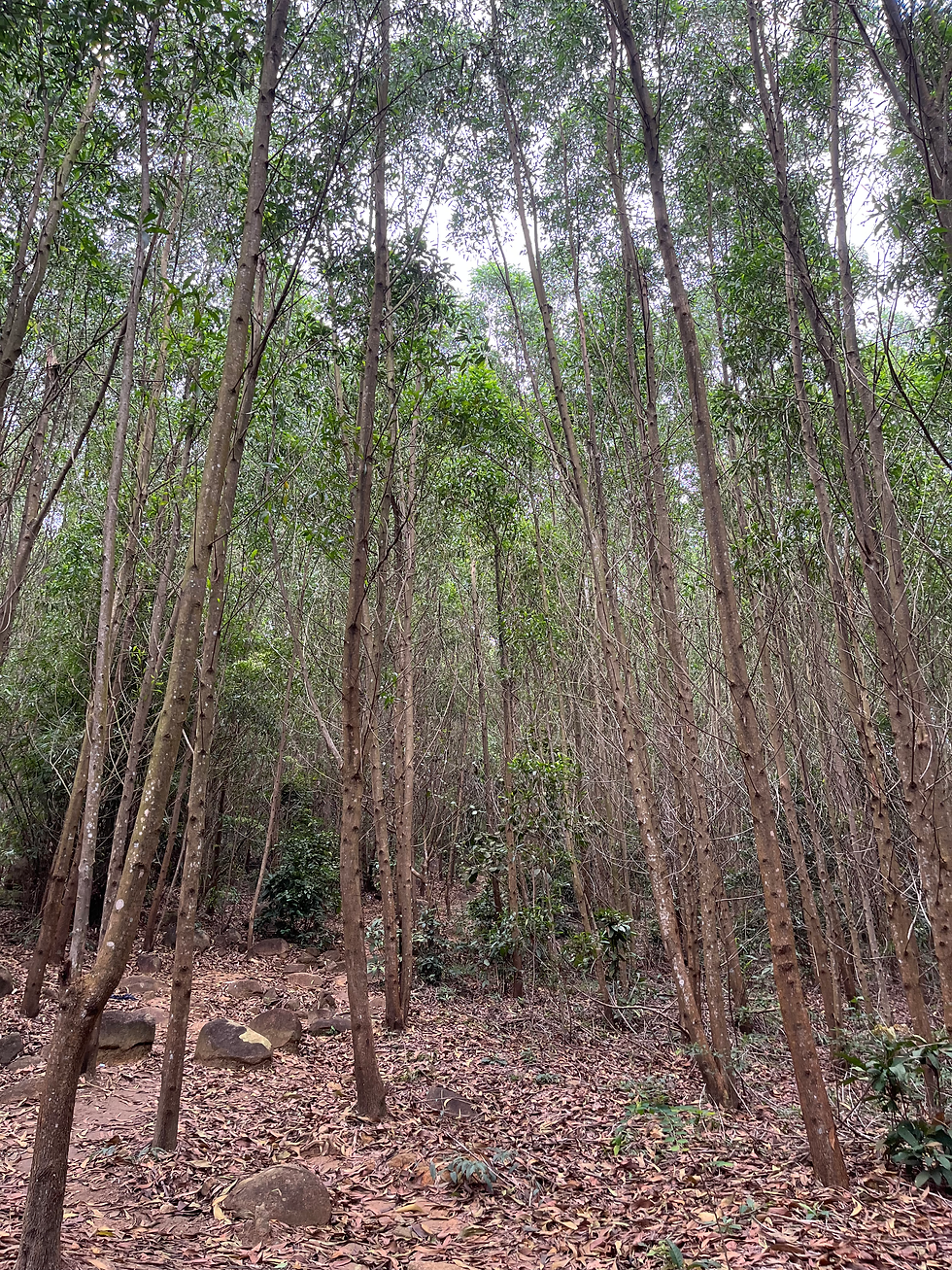
As the trail progresses, it reenters a wooded area with dense bamboo thickets, their vibrant greenery accompanied by the loud, rhythmic chirping of crickets echoing through the forest. From here, the trail begins a steeper ascent, eventually leading into what appears to be an Acacia forest.
These trees were planted as part of efforts to rehabilitate lands severely damaged by bombings and the toxin Agent Orange during the War. Local forestry programs have cultivated them, particularly in South and Central Vietnam, to restore the environment. In addition, a forest fire in 2017 affected the peak of Chua Chan, and the size of the trees suggests they were planted relatively recently. These Acacia trees are typically harvested after a 4-5 year cycle.
There are no signs or markers along the way, but the path is clear and easy to follow.


As we neared the edge of the forest, the trail led us to the ridge. The canopy faded, leaving large-leaved plants flanking both sides of the path. After about 30 meters, the trail forks—take the right, and it will lead you to the summit. At the top, a pyramid marker marks the 837m Chua Chan peak, perched atop a massive boulder, with the five-spoked star flag billowing in the wind. Reaching this point is a moment of accomplishment, having finally arrived at the second-highest peak in South Vietnam.
The left trail would lead to the transmission tower towards the power cable trail. As we were not doing a Trans hike, we backtracked to the cablecar station.

RETURN
The return journey always seems shorter than the ascent. As you near the halfway point of the hill, you’ll encounter a fork. Take the left path at the fork; if you miss it, you’ll pass through the banana plantation, but make sure to turn left when you see the blue cable car sign. The path through the banana plantation is paved but unshaded. Along the way, you’ll come across some interesting boulder formations on the left. The trail eventually merges near the launchpad area (camp area).
We were relieved to make it back without getting lost on the relatively unmarked trail. The path was quiet on the weekday, and the only hikers we encountered was a group of students leaving the peak just as we arrived.

We decided to take the cable car ride to the base. It was not more than a 15 minutes ride. The aerial view from the gondola was unobstructed and truly rewarding. I can't wait to go back again to hike up from the power cable trail.
POWER CABLE TRAIL TO CHUA CHAN
Start your hike at this point trailhead if you are thinking to ascend from the power cable route.
There is a marker at each power cable pole, it seems to start at 019 and ends at 145. The distance of each power cable are not equally apart and some are closer and further away!

Starting point : power cable trailhead
Hike Duration : appx 4 hours, 40 min
Total Ascent : 680m
Total distance: 7km
It took us over 2 hours and 20 minutes to reach the summit from the trailhead. We began our hike around 7:30 AM, with the sun blazing down on us. As we approached the rocky cliffs, we heard a loud cry that resembled a bleating goat. To our surprise, it was a young kid behaving like a dog, intrigued by our presence on the mountain and alerting the herd of goats further up.
The kid appeared genuinely curious about the two hikers attempting to scale the second highest peak in South Vietnam on that sweltering Friday morning. It hopped from one boulder to another, inching closer to us, and at one point, I was convinced it wanted to strike up a conversation! Its playful antics added a delightful touch, momentarily distracting us from the canopy of cashew nut trees overhead.


The first 2 kilometers of the hike were on rugged, rocky terrain, with the heights between the rocks and boulders wide and uneven. Much of the trail was exposed to the sun, but we cleverly chose our breaks in the patchy shade, taking the opportunity to admire the views behind us. The occasional breeze provided a welcoming relief. There were signs of drink stores that unfortunately were not opened on weekdays.


After the 145 power pole, the trail passes the radio station and descends a flight of stairs and winds for 50 meters before reaching the large boulder bearing the summit marker. The entire trail on the ridge was scenic, lined with swaying reed plants and butterflies fluttering on bushes of camomile blooms.
At a fork, veer left toward a clearing where the peak boulder stands, crowned by the red Vietnamese star flying high. The summit was empty, allowing us to fully savour the triumphant moment of conquering the second-highest peak in South Vietnam.
Back at the fork, we took the trail in the opposite direction toward the cable car station and the temple/pagoda trail. The temple trail stretches 4 km, featuring a mix of dirt paths and stairways. Alternatively, you could backtrack along the power line cable trail.
Date visited: 13st December 2024 & 7th March 2025


Comments